Alexa Dickinson
Public Spaces in the City of Boston
Looking at the city of Boston from afar, it is evident that many public spaces are reflections of their surrounding neighborhoods and their socio-economic conditions. Looking at the public spaces within our city and examining how they contribute to the community, can expose several underlying issues or benefits that affect the neighboring residences. By investigating parks and other public areas and one can see how they play a role in guiding the infrastructure around it.
The walking tour shows how different spaces serve different functionalities and contribute to different factors according to their location. Extending from Boston Common, all the way to the Arnold arboretum, this tour covers areas such as The Rose Kennedy Greenway, Christopher Columbus Waterfront Park, The Charles River Esplanade, The Underground at Ink block, Peters Park, Carter Playground, Chester Park, The Riverway, Franklin Square and Berkeley Community Garden. This extends from the north end to the south end in order to capture the differences there are between these two areas of Boston, and to be able to show all the public spaces and how they are reflections of the infrastructure surrounding them.
Here we see relationships between hosing and public spaces. this relationship can show to be complicated at times as housing normally demands public spaces while many times also taking away from it. For example, we see this both in peters park and Chester park. Peters park was crucial to the neighborhood as it was surrounded by a well standing socio-economic factors, meanwhile Chester park was pushed aside when the construction of Massachusetts avenue can along. This is an example of how a public space can be demolished due to demands for housing and infrastructure in an area. this was seen greatly through Boston’s Urban Renewal in the 1850s. This project directly affected the functionality of spaces as it demolished, took over, and changes areas completely, as we read in Rothstein’s book, The Color of Law, this shows how the economic factors in certain areas can many times determine their future, and usually for less prosperous communities, the results are not positive. This goes to show how public space and the surrounding infrastructure go hand in hand. Boston’s north and south end have deep histories with changes to economic and social factors that have led to an invisible story to be engraved within our city.
By investigating these spaces, we are also able to see how public spaces serve different purposes in different locations. For example by examining areas closer to the north end, such as Boston common, the rose Kennedy greenway, and the Christopher Columbus waterfront park, we can see the difference in access that citizens have to these open spaces, which differs from the quantity, quality, and accessibility there are to those in the south end. This may be due to economic and social capabilities of each neighborhood has, or due to other external factors.
People also play a large role in the relationship between open spaces within communities. For example, in places such as the Berkley community garden, and Titus sparrow park, people from the surrounding neighborhoods decided to come together and demand for these public spaces in order to be able to share as a community. These areas found more towards the south end were probably less economically funded, which is why they were not originally set to be there.
After vast investigation about public spaces, we can see a clear connection in how these spaces create community. we have also discovered that public spaces do not simply just mean "green spaces" but they include all sorts of areas where community members are able to come together and interact with each other. Looking to where we started, on the emerald necklace, one can see how this definition has transformed over time and location. these areas are able to transform entire neighborhoods and revive certain areas of the city to become better and more prosperous.
I believe that these public spaces are all unique to their location and all have historical and economic backgrounds that are particular to their location. In my opinion, I thought that by beginning my tour from the north end, and going down to the south end, beginning with Boston common, and ending with the Arnold arboretum made it easy show clear and steady changes. This was possible by participating in these environments and taking account of several particular aspects of them, such as the cleanliness, organization, and participation of community members seen throughout these public spaces, along with studying their histories and backgrounds. I believe that these aspects reflect how well off the societies surrounding these public spaces are or are not. By studying this relationship one can help better their community by building more community spaces in all areas of the city. This will essentially not only allow for people to come together, but also to respect the space they live in and help make it better.
Boston has had a history of many hardships that dealt with racial segregation, urban segregation, and housing segregation, but as seen through this walking tour, I believe that the addition of public spaces into communities allow for people to come together and surpass these issues. Additionally, I think that one can see hoe Boston’s entangled history with these issues has been diminished through this walking tour. As you go place by place you notice the difference from its prior state. I believe that is was due to the implementation of many public spaces that the socio-economic factors of certain communities have bettered in their situation. This shows how public spaces truly do communicate directly with the environment surrounding them, and usually for the best.
Sources:
https://www.boston.gov/sites/default/files/boston-public-garden-study-report.pdf
“History.” The Rose Kennedy Greenway, www.rosekennedygreenway.org/history/.
Staff, Boston.com. “Rose Kennedy Greenway History, Recent Changes.” Boston.com, The Boston Globe, 20 July 2012, www.boston.com/uncategorized/noprimarytagmatch/2012/07/20/rose-kennedy-greenway-history-recent-changes.
“On the Waterfront: Christopher Columbus Park.” On the Waterfront: Christopher Columbus Park | The Cultural Landscape Foundation, tclf.org/landslides/waterfront-christopher-columbus-park.
“Park History.” The Esplanade Association, esplanade.org/the-esplanade/park-history/. Lipsey, Ellon J, and Susan D Pranger. “Charles River Esplanade .” 2009, doi:10.1107/s0108768104025947/bm5015sup1.cif.
Jamaica Plain Historical Society. “A History of the Arnold Arboretum.” Jamaica Plain Historical Society, Jamaica Plain Historical Society, 30 Oct. 2005, www.jphs.org/locales/2005/10/30/a-history-of-the-arnold-arboretum.html.
“Our History " Arnold Arboretum.” Arnold Arboretum, www.arboretum.harvard.edu/about/our-history/.
“History.” Berkeley Community Garden, www.berkeleygardens.org/about/history.
"Part3:The Neighborhoods."
Community Open Space &
Recreation Mission, Boston Parks
and Recreation
www.cityofboston.gov/parks/pdfs/os3n.pdf
Bleichfeld, Avery. “Renovated Playground Brings Differing Opinions.” The Huntington News, 1 Mar. 2019, huntnewsnu.com/54934/campus/renovated-playground-brings-differing-opinions/ https://news.northeastern.edu/2018/08/02/northeastern-prepares-to-open-state-of-the-art-community-park-in-boston/.
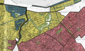
Redlining Map
Gentrification